Road Trip: The Continental US, Part One the Northeast.
- Sam Hageman

- May 9, 2021
- 13 min read
Updated: Jul 31, 2021
15,000 miles, 48 states, 42 tanks of gas, 34 days, 2 cars, 1 engagement.


On May 27, 2017 we finally departed for our USA Road Trip after months of planning, hundreds of pages full of maps & information, & hundreds of hours of research we were finally going on our first cross country road trip. We did not know what this trip would bring, but we knew it was going to be something we would never forget…& we were right.

May 27, 2017: We learned right away that things were not going to go as planned. We woke up late, because we had stayed up late to pack the car & putting together our travel binder. In the morning we still had to finish packing, closing the house for a whole month, & finish printing our information sheets & maps for the travel binder. We eventually finished everything & hit the road, frustrated & annoyed. However, we were ready to go & excited for what was to come.

We were sleep deprived, exhausted, unsure if we were truly prepared, & paranoid we did not unplug everything or lock all our windows. Even with these crazy thoughts going through our heads the excitement drowned them all out, especially when we arrived at our first stop.

(1) Cuyahoga Valley National Park, Ohio:
We drove from the Metro Detroit area three hours south to Cuyahoga Valley National Park. Cuyahoga is one of the few very pet friendly National Parks, where they are allowed on all trails, but no buildings or railroads. Most National Parks have an individual fee to enter, however prior to this trip we purchased a National Park Pass for $80 as we knew it would be cheaper due to the number of parks we would be visiting, saving us a ton of money.
When we arrived to Cuyahoga we were in the middle of the woods away from cities, the only sign of civilization was the cars in the parking lot. We stretched out & hit the bathrooms before embarking on Ledges Trail. Ledges Trail was a beautiful hike, the trail started in the forest & slowly turned into rock ledges surrounding us. Eventually we dropped down below the cliffs & were surrounded by amazing rock formations. We discovered Dexter’s love for climbing rocks & looking over the edges of cliffs. Although he was cautious, he loved looking what was down below or seeing how high he could climb. The Ledges Trail is 2.2 mile loop that includes rock formations, ledges, & an overlook of the entire valley. Due to our late departure & time constraints we were not able to do the entire trail or other trails we considered checking out.
Other trails we looked into & recommend checking out:
(a) Brandywine Gorge Trail (1.5 mile loop, including Brandywine Falls).
(b) Bedford Reservation/Tinker’s Creek Gorge Scenic Overlook.
(c) Buckeye Trail on the Bedford Reservation (0.5 mile loop, including Bridal Veil Falls).
This is a place we hope to return to in the future.


(2) Niagara Falls State Park, New York:
From Cuyahoga we drove about four more hours to Niagara Falls. This is was more of a tourist stop than a real hike, as it is all paved trails & buildings/attractions. It was expensive to park close to the Falls, so we parked farther away in a free area & walked along the water to Niagara Falls. Niagara Falls on the American side is free except for attractions & if you pay to park closer than we did. There were hundreds of people there & it was crowded, especially because it was a holiday weekend. Dogs are allowed on leash everywhere but buildings & attractions, just be cautious of how your dog reacts with large groups of people & make sure they are not too stressed out. To get farther away from the crowd we walked the Niagara Gorge Rim Trail & across a bridge to Goat Island where things were less crowded. From here we could view the American Falls above & were right next to Horseshoe Falls. We would like to visit from the Canadian side to see a different perspective & do some more tourist attractions. After exploring we headed out & decided to go straight to our campsite instead of our last stop (as it was close to camp), so we would hit it in the morning.

(3) Stony Brook State Park, New York:
We drove about two hours to our campsite in New York. It was dark & we could not see where the campground was. We ended up driving around it a few times before finding the entrance, as it was not marked very well. Thankfully there were restrooms & showers in the campground, so we hit those before setting up camp. The showers were gross & dirty, plus you had to practically walk through someone’s site to the bathroom. After a less than great time in the bathrooms, we set up camp in the dark (which was a complete pain). Thankfully we were prepared with a quick-set-up tent, tent light bulb, & inflatable air mattress, so it did not take too long. We also did not have electricity at the campsite (& knew there would be many sites where we wouldn’t), so we came prepared by purchasing a power inverter (car lighter to 3-prong power strip) that worked wonders & saved us from sleeping on the hard ground by using our car to blow up the air mattress. We were exhausted & beyond ready for bed after our long day, but we swore to ourselves we had a better plan for day two & beyond.

May 28, 2017:
The next day we woke up early, but maybe still not as early as we should have. We started by reorganizing the car, because it was not very functional for the trip (I will do an entire blog on packing, including how to pack a car). After re-packing the car for an hour & getting some food, we packed our camping gear & discussed our plans for the day. We skipped everything at Stony Brook State Park we had wanted to do, but these are the places we wanted to go & hope to eventually go one day:
(a) Gorge Trail (1 mile, including 3 major waterfalls).
(b) West Rim Trail (1 mile).
(c) East Rim Trail (1.5 miles).

(4) Letchworth State Park, New York:
After Stony Brook we drove 30 minutes to Letchworth State Park, aka the “Grand Canyon” of the East Coast. We paid $10 & received a map of the park. We had only given ourselves an hour to look around Letchworth since it was on our way to the next stop. We drove around to a few overlooks, one view of the dam & the other view of the mountains. We drove all the way through the park but were unable to go on any of the trails due to time constraints. The places we wanted to go were:
(a) Gorge Trail (9.2 miles, many scenic overlooks, Inspiration Point, waterfalls, and views of the gorge).
(b) Genesee Valley Greenway Trail (5.75 miles, Inspirational Falls, Deh-ga-ya-soh Falls, Deh-ga-wa-nus Falls, and Bubbling Tier Falls).
(c) Seneca Trail (0.75 miles, descends into the gorge edge of the Genesee River).
(d) Smokey Hollow Trail (2.25 miles, down into the gorge with great views of Horsetail Falls and Detour Cliff Cascade).
Dogs were allowed everywhere on leash, except for buildings. Although I am not sure if Letchworth can be compared to the Grand Canyon, it was beautiful for what it was.

(5) Bog River Falls & Coney Mountain, Adirondack Mountains, New York:
It took us 4.5 hours to get to Bog River Falls in the Adirondack Mountains. There are so many amazing places you can visit in the Adirondacks, but we planned ahead to spend most of our time in the Tupper Lake area at Bog River & Coney Mountain. Dogs are allowed on leash everywhere in the Adirondacks, except the Ausable Lake area, & there are some areas that allowed off-leash dogs. Most of the trails & areas are also free in the Adirondack Mountains, but make sure you do your research of the area first.

We originally passed Bog River Falls on our drive since they were not marked, but we realized the falls were right next to the bridge after we drove few minutes & turned around. Bog River Falls were right behind the stone bridge. We walked behind the parking/bridge area, jumped on some rocks, & splashed in the water. The view was incredible for such little falls that poured into the river under the bridge. It was a nice stop, except for the mosquitos…they were AWFUL. Be prepared with tons of bug spray or repellent of some kind in this area.

Next, we headed to Coney Mountain only a few miles away from Bog River Falls. The trail was located on Route 30 a few miles south of junction of Route 421. Although it was not supposed to have a dirt lot, the area had just added a dirt parking lot at the trail head to Coney Mountain. The trail was 1 mile & we climbed 530 feet, making it a more moderate hike. There were some small inclines & declines along the trail, but the worst incline was at the end to the top of the mountain. It was slick from the rocks & a steep incline, thus we had to let Dexter run up off leash to prevent any injuries. Due to my asthma & the incline I was forced to stop occasionally. However, after the struggle of getting to the top the view was well worth it. It was absolutely beautiful & we were able to watch the sunset. The only downside was the mosquitos but given the weather & the time of day it was to be expected. The hike down was a bit easier since we knew the path, we just had to be cautious of the steeper inclines.

Once we left the sun was finally set & it got dark pretty fast. We drove about an hour until we reached our campsite at Wilmington Notch State Campground. We once again set up in the dark, which we hoped to avoid the next day. However due to time restraints we did skip a few places we wanted to go;
(a) Cascade Mountain (4.8 miles, with an amazing 360 degree view of the mountain, but many be crowded. You can add 1.4 miles to your hike you can climb Porter Mountain, which is less crowded).
(b) Whiteface Mountain (You can access this from the road. It has a paved walkway to an elevator which brings you to the top. You can hike it, but it is very dangerous & should be done by very fit & experienced hikers).
These are just some locations. The Adirondack Mountains are massive & there are so many places to travel & explore.

The Wilmington Notch State Campground was nice & had clean bathrooms/showers. Although we had no electricity, we were equipped to handle it. It was overall a very nice place to camp.


May 29, 2017:
(6) Dog Mountain, Vermont:
The next morning, we drove 3.5 hours until we arrived at Dog Mountain. The weather was rainy & cloudy, but we still made the most of it. Dog Mountain was a gem & free for all. It was so unique compared to most places we went. Dog Mountain is technically an art gallery & was established by the artist Stephen Huneck. It is a dedication to his dogs & all other dogs who have been lost. It is the only dog chapel in the country where you can write a message & put a photo of your dog on the wall. The walls are full of beautiful stories & photos of dogs & their owners. The chapel has beautiful art & stained glass windows. Outside the chapel, there were other art pieces & statues, a dog obstacle course, giant fields to run around in, a pond to swim in, & some trails to hike to the top of the mountain. There was also an art gallery with a restroom & beautiful dog art. The whole place allows dogs off leash & in buildings. It was a beautiful place & a great place to remember one’s dogs. If you are in the Vermont area, I highly recommend stopping in.

(7) Mt. Washington State Park, New Hampshire.
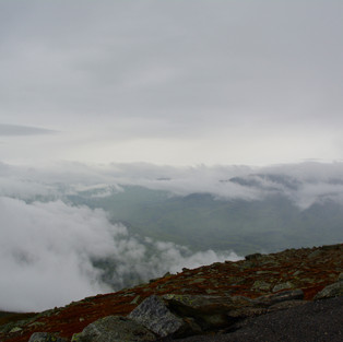
Once we wrapped up at Dog Mountain we drove about 2 hours to Mt Washington State Park. It was a very foggy & rainy day at the bottom of the mountain, but we still wanted to go up. You can hike up it, but there is the option to drive up. A lot of people say it is better to go on a clear day to see everything. The weather on the mountain is always different then the weather below though. So you can check their website for the mountain top weather. After we paid $40 for the car, driver, & passenger, we drove up the mountain. However, we had to go very slow, keep the car in first gear all the way up, & it took about an hour to drive up. It was terrifying for me, because we were on the edge of a mountain with no barrier, fog surrounding us, with small glimpses for how far down it was. Thankfully the Ford Escape we were in was able to make it up without a problem, but we did see others facing overheating engines along the way. However, Mt Washington has some pull off areas on the way up or down the mountain & cooling stations in case of overheating. When we got to the top, the winds were heavy, it was freezing, & it was hailing. Dexter attempted to go out, but he eventually was so cold that I ran him back to the car after only a few minutes. Dogs are allowed on the grounds, but sadly not in any buildings of Mt. Washington, so the only shelter he had was the car. Garrett ran in the buildings to look around more, but the weather was so bad that we decided to get out of there. The drive down was a lot easier to handle since we drove next to the mountain. Plus, it cleared up a little & we could see some stuff, but the clouds were still very heavy. During the trip we were also given a CD to listen to giving us information about the history of the mountain. Overall, it was a cool stop, but it would have been better on a clear day.


(8) Acadia National Park, Maine.
We then started our 5 hour drive to Seawall Campground in Acadia National Park. We made a pit stop about 2.5 hours outside of Acadia at Fast Eddie’s Drive-In in Maine for dinner. They had fantastic milk shakes & the standard burgers & fries. It was an amazing stop in Maine & a cute little place that gave Dexter a free vanilla ice cream bowl.

Once we finally hit the road again it was dark & it was pitch black driving through Acadia. We saw a lot of animals & I kept an eye out for the wildlife while Garrett drove. This was the first of many times we almost hit a deer on this trip. However, once we reached camp the pitch-black night made it perfect for star gazing. Seawall is a beautiful campsite, without electricity or showers. We set up camp with some struggles. The car is a little bit of a distance from the tent, so we had to use the power inverter to blow up the air mattress outside the tent, then shove the bed in the tent after. However, after struggling with the bed we were able to stare at the stars right above our heads. The bathrooms were very clean & not far from all the sites. The best part about this campground is how secluded each site is, because they are all surrounded by trees & a little bit away from the main road of the campground. It was one of the nicest camp sites on the trip.

May 30, 2017:
(8) Acadia National Park, Maine.
Thankfully we were smart & planned to spend two nights in Acadia, giving us a whole day to explore (although it still is not enough time). This also allowed us to catch up on some sleep & sleep in a little. After we ate breakfast, we wanted to check out as much of the park as possible. This was best done by driving. We had to purchase a map, because we did not have one & they do not give them out for free.

While we planned a route, one thing we didn’t have to worry about was dog locations for the most part. One of the coolest things about Acadia is it is one of the most Dog Friendly National Parks. They even have a National Bark Ranger Video, which I would highly recommend as it is very cute. Dogs must be on leash. Dogs are not allowed to swim in any of the lakes or at the Echo Lake & Sand Beach. Dogs are not allowed in the wild gardens of Acadia (Sieur de Monts). Dogs are allowed on all trails, except trails dogs cannot physically do; Precipice, Beehive, Ladder Trail to Dorr Mountain, Beech Cliffs Trail, Perpendicular Trail (Mansell Mountain), Jordan Cliffs Trail between Penobscot East Trail & the carriage road. Acadia also recommends to not take dogs on these trails for safety reasons; Acadia Mountain, Flying Mountain, Giant Slide, Cadillac Mountain- west face, Bubble & Jordan Ponds Path, between the carriage road &The Featherbed pond, Norembega Goat Trail, Bubbles-Pemetic Trail, Penobscot Mountain (Spring) Trail, Upper Beachcroft Trail, Upper Gorge Trail.

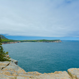
After we grabbed the map we started to drive around the Northeast half of the park, taking stops at some of the look outs. We stopped at Bar Harbor in hopes we could hike to Bar Island. However we did not know the tide times & were too late. You can only get to the Bar Island during low tide as there is a walking path across the ocean. We got there right as high tide was coming in. We even watched multiple people who forgot to get back before high tide run back to shore or even partially swim from the island back to shore quickly. There were even rescue trucks ready to speed across & grab people before the tide became too heavy. Even though we missed it, we walked around the shore & went to one of the many dog friendly restaurants in the area, Stewman’s Lobster Pound Downtown. The restaurant has a patio right by the docks & they even have a dog menu. Every dog who came in got their own bowl of water too. They had good food & we had great service as well.

Once we finished up in Bar Harbor, we continued our driving tour around Acadia. We stopped at the top of Cadillac Mountain. The view was beautiful & you could see almost the whole park. It was beautiful, but it was very crowded. Once we finished up there, we picked up some food to cook & headed back to camp. When we were done with dinner, we attempted to find a spot to see the sunset near Seawall, however we did not see the sunset. Instead, we went to the Bass Harbor Head Lighthouse & hopped around the rocky shoreline. Dexter had a blast being on the cliffs edge of the Atlantic Ocean & loved hopping along the rocks. When we wrapped up, we headed back to camp for the night & enjoyed the amazing stars again. Like every stop on our trip, there were plenty of places we wished we could have gone, but were not able to, including:
(a) Bar Island Trail (2 miles-walk over during low tide to a forest island).
(b) Schooner Head Path (5.4 miles with overlook of the ocean).
(c) Compass Harbor Trail (0.8 miles).
(d) Evergreen Forest Rocky Coastline (1.4 miles).
Acadia has plenty more to offer & tons more trails we would have loved to go on, but we knew we would not have the time for. I highly recommend it for anyone.


Comments